 SSC Users Guide - Table of
Contents
SSC Users Guide - Table of
Contents
Models and Regions of Geospace in the Satellite Situation Center
Software, V. 2.2
(Hitchhiker’s Guide to the SSC Geospace)
As part of the modernization of the magnetic field
models and geospace region definitions used in the
Satellite Situation Center (SSC) software, a radical change was
introduced between Versions 2.1 and 2.2 in terms of the philosophy used
to define regions of geospace. Versions 2.1 and earlier essentially
employed a single “index” to identify regions, without distinction
between regions in space and regions on the ionosphere (or ground).
Version 2.2, in contrast, involves multiple indices to specifically
differentiate the region in geospace that the satellite resides in, and
the (mapped) regions on the ionosphere (or ground) that the subsatellite
point or magnetic footpoint(s) fall in. Thus, the new geospace region
definitions involve a family of “spacecraft regions,” and a family of
“mapped regions,” as listed below:
Regions of Geospace
Spacecraft Regions:
| Spacecraft Region | Code recorded when output = CDF |
|---|
| None | 0 |
| Interplanetary Medium | 1 |
| Dayside Magnetosheath | 2 |
| Nightside Magnetosheath | 3 |
| Dayside Magnetosphere | 4 |
| Nightside Magnetosphere | 5 |
| Plasma Sheet | 6 |
| Tail Lobe | 7 |
| High Latitude Boundary Layer | 8 |
| Low Latitude Boundary Layer | 9 |
| Dayside Plasmasphere | 10 |
| Nightside Plasmasphere | 11 |
Mapped Regions:
| Mapped Region | Code recorded when output = CDF |
|---|
| None | 0 |
| Northern Cusp | 1 |
| Southern Cusp | 2 |
| Northern Cleft | 3 |
| Southern Cleft | 4 |
| Northern Auroral Oval | 5 |
| Southern Auroral Oval | 6 |
| Northern Polar Cap | 7 |
| Southern Polar Cap | 8 |
| Northern Mid-latitude | 9 |
| Southern Mid-latitude | 10 |
| Low-latitude | 11 |
Users may request, independently, information on any of the four region
identifier indices: 1) spacecraft region, 2) radially mapped region
(i.e. the subsatellite point), 3) northern magnetic footprint region, 4)
southern magnetic footprint region. Magnetic field traces are performed
using a user-selectable combination of internal and external magnetic
field models.
Regions and Boundaries in the SSC Software: Algorithms
Spacecraft Regions:
The Interplanetary Medium, Magnetosheath, and Magnetosphere regions are
defined by model boundaries for the magnetopause and bow shock surfaces.
For the Magnetopause, the Roelof and Sibeck model (JGR, 98, 21421,
1993) is employed. The model represents the boundary as a “quadratic
function” in aberrated GSE coordinates; namely:
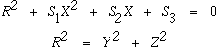
where S1, S2 and S3 are functions of the solar wind dynamicd pressure
Psw and the IMF-Bz component.
For the Bow Shock, a Modified version of Fairfield’s 1971 model
(JGR, 76, 6700, 1971) arranged to move in and out in response to
solar wind and IMF changes, in unison with the magnetopause, and
constrained to fixed ratio between the subsolar distances to the bow
shock and magnetopause, Rbs/Rmp=1.3
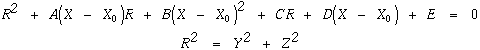
The Neutral Sheet definition is based on the current sheet model
used in new Tsyganenko models (JGR, 100, 5599, 1995). The current
sheet surface is described by the expression:

where (x,y, z) are aberrated GSM coordinates, psi is the tilt angle, and
the “scaling” parameters are set to: Rh = 8, d = 4, G=10, Ly = 10.
The Plasma Sheet model, as labelled in the SSC, is meant to include
both the plasma sheet (PS) and plasma sheet boundary layer (PSBL) since
no community-accepted models exist (as far as we know) to represent
these regions independently. The PS region is thus defined as a strip
extending 3 Re above and below current sheet surface.
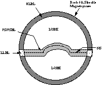
The High Latitude Boundary Layer (HLBL) and Low Latitude Boundary
Layer (LLBL) regions are defined in relation to the magnetopause and
neutral sheet. Using GSM coordinates, an anular strip of thickness D =
D(X) is defined inside magnetopause; D widens from 0.4 Re at the
terminator to 4 Re at X=-40 Re, and is held fixed at 4 Re tailward of
X=-40 Re. Points inside the strip and within 3 Re of the neutral sheet
surface are labelled as LLBL, while those in the strip but more than 3
Re from the neutral sheet are tagged as HLBL.
The Tail Lobe region is defined as points tailward of the “hinging
distance” (Rh = 8), inside the tail but not in PS, HLBL or LLBL.
The following diagram illustrates graphically, the layout of the regions
described above:
The Plasmapause is defined according to the model of Gallagher, et
al., (Adv. Space Res. 8, 15, 1988) which represents the plasma
density n as a function of the L-parameter, the magnetic local time
(MLT) and the height, h, above the Earth’s surface.

In the previous expression, lambda is the geomagnetic latitude. We
define plasmapause as the surface give by log(n)=1.5 The region labelled
Magnetosphere corresponds to points inside magnetopause but not in
other s/c regions.
Mapped Regions:
The Cusp and Cleft regions are based on “statistical” description
by Newell and Meng (JGR, ???); namely, the Cusp is defined as the region
MLAT= 75-76 degrees, MLT=09:00-13:00, while the Cleft is given by MLAT =
74-78 degrees, MLT=08:00-13:30.
The Auroral Oval boundaries AOHI and AOLOW are described by:
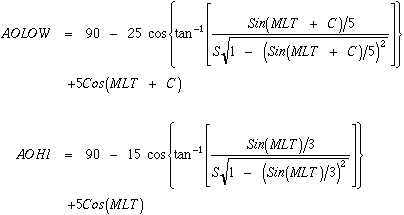
where C=22.5 degrees if MLT<22:50 and 337.5 degrees if MLT>22:50;
S=+/-1 (nightside/dayside).
Finally, the Mid-latitude and Low-latitude regions are defined in
terms of ranges in MLAT according to: Mid-lat from MLAT = 30 degrees up
to the equatorward edge of auroral oval, and Low-lat by MLAT = -30
degrees to 30 degrees.
The various mapped regions are illustrated in the following sketch:

SSC Users Guide - Table of
Contents
